
Cedar Creek Watershed Planning Process is Underway at Pierce Cedar Creek Institute!
Cedar Creek Watershed Planning Process is Underway!
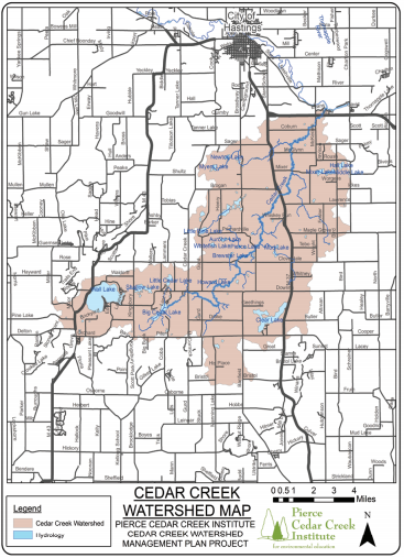
Cedar Creek winds its way through central Barry County and is one of the defining features of the Institute’s 829 acre property. Largely seen as a pristine and natural waterway whose shores and waters harbor many wildlife and plant species that are symbols of our native landscape, current and future threats to water quality within the Cedar Creek watershed led the Institute and its partners to secure grant funding through the Michigan Department of Environment, Great Lakes, and Energy’s (EGLE) Nonpoint Source Program by the United States Environmental Protection Agency (USEPA) to develop a Cedar Creek watershed plan.
The Cedar Creek Watershed Planning Project, a two-year grant project, will assess current threats to Cedar Creek, Wall Lake, Clear Lake, and Big and Little Cedar Lakes. These assessments include E.coli and water chemistry monitoring, sediment and nutrient load levels, fish and macroinvertebrate surveys, land protection, shoreline inventory, and a policy review of existing ordinances within the watershed. The primary goal is to develop a comprehensive USEPA-approved watershed management plan that can be used by organizations to implement practices or strategies outlined in the plan to improve water quality.
Existing monitoring data shows impairments within Cedar Creek; high levels of E. coli and degradation of fish habitat due to increased sediment and nutrient loading limit the fishing, kayaking, and swimming recreation within portions of Cedar Creek. Institute staff and research partners, including Dr. Eric Snyder of Grand Valley State University and Aaron Snell of Streamside Ecological Services, are collecting vital data that will form the water quality improvement strategies. Technical assistance is being provided by EGLE Nonpoint Source Pollution staff.
Since much of the land within the watershed is rural agricultural or natural area, partners such as the Southwest Michigan Land Conservancy, Barry Conservation District, and Public Sector Consultants will contribute to developing a land protection strategy for priority areas in and around Cedar Creek, Wall Lake, Clear Lake, and Big and Little Cedar Lakes. This project also includes a social monitoring component, which uses feedback from the community and stakeholders to determine how best to implement the watershed plan and what the priorities are from a variety of perspectives.
The Institute will be hosting regularly scheduled steering committee and informational meetings regarding the progress of the Cedar Creek Watershed Management Plan, so check out the Institute’s website, Facebook, and emails for more information. If you wish to learn more about the planning process, contact Stewardship Manager Corey Lucas at (269) 721-4198. This project has been funded in part through Michigan Department of Environment, Great Lakes, and Energy’s Nonpoint Source Program by the United States Environmental Protection Agency.